color

Looking at Appalachia | Jeff Rich

Jeff Rich is a photographer and educator based in Iowa City, Iowa. His long form project, The Watershed Project, first caught my attention a few years back when I learned of it via Photolucida. Rich also curates the 'Eyes on the South' photo blog for Oxford American. We spoke a while back about featuring some of his work here and he was also kind enough to answer a few questions in the midst of a busy summer. Thanks, Jeff!

3 Jeff_Rich_5

4 Jeff_Rich_6

Clearly the issues addressed in Watershed aren't unique to Appalachia. Nationwide, worldwide, people are working to protect watersheds from issues like runoff and loss of habitat. Working specifically in Appalachia though, did you face unique cultural or environmental challenges?

Working in Western North Carolina was the first time I had really researched and documented issues like these. However throughout my research I have learned a lot about watershed management. As you say most of the issues faced here are the same in every watershed.  I intentionally focused on these problems because in many ways the French Broad can be seen as a microcosm of much larger watersheds, like the Mississippi River Basin.  As for being unique, the Central Appalachian mountains are one of the most biologically diverse regions in the country. Culturally there were no challenges, I found that people in the watershed were very interested in keeping the river clean and livable.

5 Jeff_Rich_3

6 Jeff_Rich_9

7 Jeff_Rich_17

I know as a kid growing up on the Tug River, which separates West Virginia and Kentucky, I always saw polluted creeks and streams. Part of what I saw were remnants from flooding and the trash left behind, but it wasn't uncommon to see folks just pitch their garbage over the riverbank. It was sort of like the concept of throwing something "away" meant pitching it into the river and letting the river carry it away. Did you see any evidence of this mindset in the areas of North Carolina and Tennessee you worked in? I'm just curious as to whether it's more of an isolated mode of thinking or if it's more common than that in mountain communities.

One of the reasons I started this project was to document the visual effects of this mindset that the river is our toilet. Evidence of this can be found throughout the region, and when I first started this work I focused on that pretty heavily. I found that it is a problem throughout the region, whether it is in the big cities or smaller communities. However, on the flip side of this is the progress that this area has made over the past 40 years. The French Broad River is much cleaner now than it ever was in the past 60 years. I find that people are much more aware of what is upstream of them because of pollution in their towns. Consequently residents awareness is much higher now of what is downstream.

8 Jeff_Rich_8

9 Jeff_Rich_20

10 Jeff_Rich_14

You're work reminds me that it isn't just the mountains that make Appalachia what it is, it's also the water. Can you talk a little bit about the relationship between the two and how your work incorporates these visual elements?

I've heard it said that the French Broad River is the third oldest river in the world, and that it is even older than the Appalachian mountains that surround it. With the birth of the Appalachians at about 480 Million years ago, I find this geologic history inspiring. One of the things I wanted to do with this work was really document this moment in this history. How do we effect this landscape which has a lifespan that really dwarfs our own history? Especially in post-industrial terms, in this time-scale we have only just started to effect the landscape in significant ways. Because of the topography of the area, many of the cities have water running right through the middle of town. These rivers have formed the valleys where most people live. I found that some of the towns embraced the rivers and creeks, while others ignored them. This relationship with the rivers forms the visual base of much of my work in the watershed.

11 Jeff_Rich_7

12 Jeff_Rich_11

13 Jeff_Rich_2

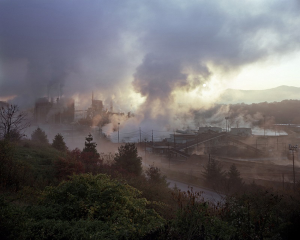
There's an unmistakable beauty in your work, which requires the viewer's gaze. The image of the Blue Ridge Paper Mill comes to mind. Can you talk a little about what's going on (i.e. there's this really arresting photograph, bathed in perfect light, rich color, yet it's a paper mill releasing all sorts of chemicals into the air and no doubt the water)? This is something you're putting in front of the viewer and asking them to deal with right?

Yes, absolutely. I want the viewer to have a similar experience to my own when I first encountered the mill. I experienced what I have heard called an industrial sublime. In other words I was awestruck in the face of industry.  I find this fine-line between beauty and the environmental reality of the situation is a fascinating thing to document.

I returned several times to photograph the plant over the span of about three years and each time I am amazed at how the mill dominates the valley. Each time I returned to the mill to photograph it, I ended up with images that described the appearance and size of the mill, but I never captured an image that portrayed the effect of the mill on the surrounding landscape. The effect of the mill was what I was most interested in, since this mill was one of the largest polluters of the area for most of the 20th century. The Pigeon River which runs right through the center of the plant was used for all of their waste water and as a result was heavily polluted, negatively effecting downstream communities all the way to Newport, Tennessee.

14 South Holston Dam

15 Holston Weir Dam

16 Calderwood Lake

How do you see the final project being put out into the world? Three separate books under the umbrella of Watershed?

Yes, the Watershed project is ongoing. I am following the water all the way down to the Gulf of Mexico, via the Tennessee River, and finally the Mississippi River. The ultimate goal is to have the work in three separate books. Currently I'm documenting the TVA's (Tennessee Valley Authority) effect on the region. The TVA was the largest New Deal project and had an enormous impact during the twentieth century. I have also started documenting flood control measures taken by the Army Corps of engineers along the Mississippi River.

I have created an interactive project website that maps the rivers and photographs and gives a bit more background information. which can be seen at watershed-project.com.

17 Road to nowhere

18 Dam Walkers

19 Forest_Fire

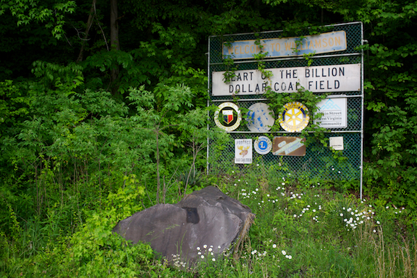
Most of the environmental issue portraiture about Appalachia that exists today is about mountaintop removal coal mining. I don't see your work as a break from that, but rather a supplement to raising awareness of what's going on in these ancient hills. Can you talk about that?

I think that mountaintop removal is one of the biggest issues facing the region. Doing a project like Watershed is definitely about raising awareness, not only of current exploitation of resources, but also showing what's at stake.  I think that's what is most important to me, showing the problems, but also showing what we could possibly lose in the process.

20 cumberland_plant

21 Jeff_Rich_24

22 Jeff_Rich_23

23 20_Jeff_Rich-950x760

24 Jeff_Rich_15

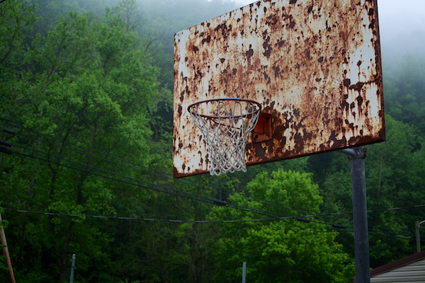
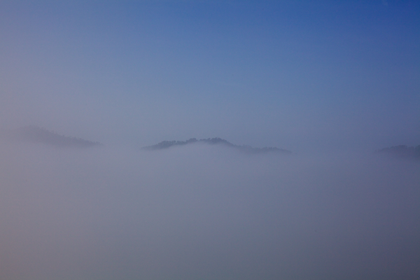
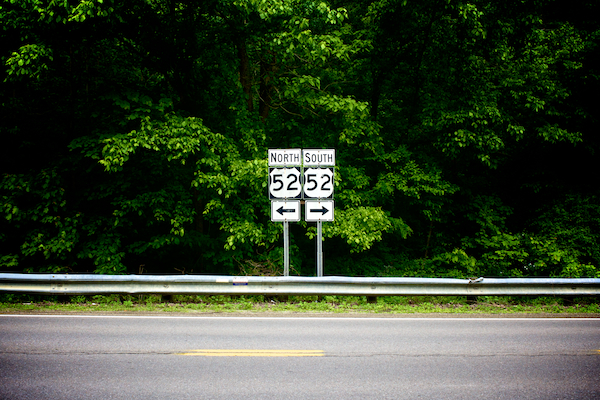
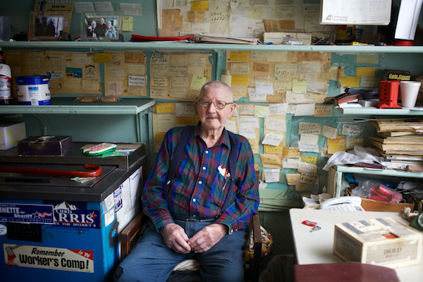
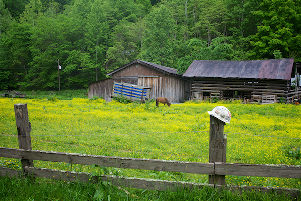
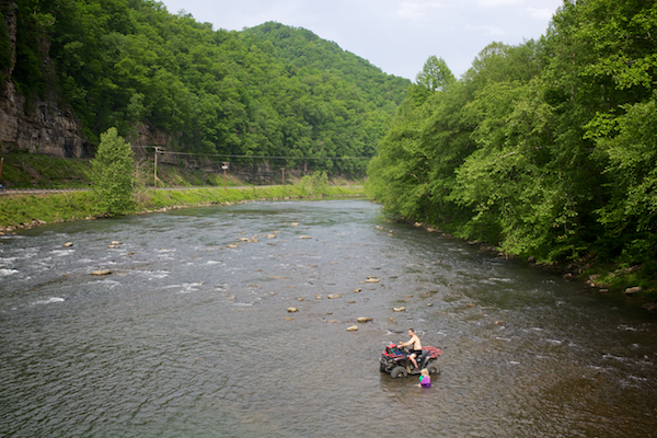
1. Blue Ridge Paper Mill, Pigeon River, Canton, North Carolina, 2008 2. Bridge Reconstruction - The French Broad River, Marshall, North Carolina, 2006 3. River Clean-up on the Swannanoa River, Asheville, North Carolina, 2007 4. Cement Plant, Asheville, North Carolina, 2006 5. Benjamin and Katie, French Broad River, Asheville, North Carolina, 2008 6. Garden, North Toe River, Spruce Pine, North Carolina, 2007 7. Foam from upriver pollution, Pigeon River, Tennessee, 2007 8. Crossing, Swannanoa River, Asheville, North Carolina, 2005 9. Toe River, North Carolina, 2007 10. Mitch and Mike, The French Broad River, Stackhouse, North Carolina, 2007 11. Brown family farm, North Fork of the Swannanoa River, Black Mountain, North Carolina, 2007 12. Ski Lift, Little Pigeon River, Gatlinburg, Tennessee, 2007 13. Barber Orchard Superfund Site, Waynesville, North Carolina, 2007 14. TVA South Holston Dam, South Fork Holston River, 2012 15. South Holston Weir Dam, South Fork Holston River, 2012 16. Calderwood Lake, Little Tennessee River, Vonore, Tennessee, 2012 17. Road to Nowhere (North Shore Road) Great Smoky Mountains National Park, Tennessee, 2012 18. Fort Patrick Henry Dam, South Fork Holston River, Kingsport, Tennessee, 2012 19. Forest Fire and I-24, Mill Creek, Whiteside, Tennessee, 2011 20. Fish Kill, Cumberland Fossil Plant, Lake Barkley, Cumberland City, 2011 21. Raccoon Mountain Pumped Storage Plant Outflow, Tennessee River, Chattanooga, Tennessee, 2010 22. Watts Bar Nuclear Plant, Tennessee River, 2010 23. Glenn on his dock, Coal Fly Ash Spill, Kingston, Tennessee, 2009 24. Coal Fly Ash Spill, Harriman, Tennessee, 2009

All photographs © Jeff Rich.

Sketches from Appalachia | May 2013

I was able to spend a few days back home last weekend making photographs and visiting with friends and family. I left Raleigh after work Thursday and made it to my Aunt Rita's house in Red Jacket, West Virginia around 1 a.m. Friday. After a few hours of sleep, I was up and out the door by 7 a.m., anxious to make pictures, when I saw this basketball goal, which I've seen hundreds of times. I wandered over to make a few frames. Given the morning fog, I knew there was a potential for nice images up higher on the King Coal Highway. From there, I wandered over to Williamson, backtracking through Matewan on WV Route 49 to US Route 52.

After breakfast at The Righteous Brew coffeehouse in downtown Williamson, I met up with Eric Mathis, my good friend and city commissioner with the Williamson Redevelopment Authority, to talk about Sustainable Williamson and make a few site visits in Mingo County. Later in the afternoon, I wandered in to Pecco's Carry Out in Williamson, and did something I'd wanted to do for years - strike up a conversation with Mr. Pecco (below) and make some pictures of him. He told me a few stories about various floods, what it's like to be in business at the young age of 91, and meeting John F. Kennedy. I made several digital pictures (SLR and iPhone 5) as well as two Fuji Instax 210 instant prints, leaving him with one along with my sincere thanks.

IMG_5487

IMG_5498

Saturday morning greeted me with more early morning fog, which provided a nice backdrop for the image below, made near Rawl, West Virginia on WV Route 49. From here, I headed back to Williamson to meet Jenny Hudson, director of the Mingo County Diabetes Coalition, at the Williamson Farmers Market. Brothers Doug and Jerry Dudley offered me a chair and a cup of coffee and we talked about farming, life, and how Appalachia is often (mis)represented in photographs. I bought some cantaloupe and tomato seedlings from Doug and he invited me to spend some time on his farm in Aflex, Kentucky, which I fully intend to take him up on. In fact, I told him later that day I wanted him to adopt me. He's that kind of salt-of-the-earth guy. The real deal.

IMG_5525 (1)

IMG_5532

Later Saturday, I got a chance to photograph the reenactment of the Matewan Massacre, something else I'd wanted to photograph for years. If you're not familiar with this part of West Virginia, and ultimately national, history, do yourself a favor and watch John Sayles' 1987 film Matewan (Chris Cooper, James Earl Jones, Mary McDonnell). Eric Simon (below), of Williamson, West Virginia, played the role of Matewan Chief of Police Sid Hatfield. In Matewan, I met up with NPR-affiliate West Virginia Public Broadcasting's Dave Mistich, who drove down from Charleston to talk with me about Testify and my Mingo County roots. The piece aired yesterday, 23 May 2013. You can read it here and listen here.

IMG_5605

Screen Shot 2013-05-24 at 12.19.41 PM

Sunday morning, I went to church with Rita at the Chattaroy Church of God. She hardly ever misses church and it was an opportunity for me to spend some time with one of my favorite people on the planet. We stayed after church a while for the spaghetti dinner hosted by the youth group, then it was back to Red Jacket to load up and head back to Raleigh.

Leaving home is always the hardest part, but on my way out of Mingo County, heading south on US Route 52, I made a few more pictures. I stumbled on this farm scene with a miner's helmet on the fence post. You just can't make this stuff up. Then, in Gilbert, I saw a father and daughter in the river as I drove by. I turned my truck around, knowing I wouldn't forgive myself if I didn't stop and make it. I hollered down to Jamie on his four-wheeler in the Guyandotte River and asked if I could make a few pictures. He obliged and actually thanked me for asking first. After a few digital captures, I made a single instant film picture and left it, along with my contact information, on the riverbank for them.

IMG_5621

IMG_5629

I also had the great fun of "taking over" the AARP Instagram feed for a couple of days while I was in Mingo County. You can see the iPhone images I shot here.

Screen Shot 2013-05-24 at 1.36.28 PM

Looking at Appalachia | Joshua Dudley Greer

25 Joshua Dudley Greer is a Visiting Assistant Professor of Photography at East Tennessee State University in Johnson City, Tennessee. His series, Point Pleasant, caught my eye some time ago because of its Appalachian connection. The project also stood out to me as an anomaly of sorts of fine-art Appalachian landscape photography. There seems to be no shortage of "gritty*" documentary photography and photojournalistic projects about Appalachia, but I've had a hard time finding landscape work outside of the Smoky Mountain or Appalachian Trail genre. (Andy Adams' fantastic Looking at the Land exhibition, featured six photographs from Appalachian states as well as an image of Greer's from California.)

While researching the 1967 Silver Bridge collapse and its connection to the Mothman legend, Greer learned of a nearby TNT complex whose subject matter eventually came to construct the series. He agreed to share some of his work from the series. The Point Pleasant project statement:

The West Virginia Ordnance Works (WVOW) was an explosives manufacturing facility constructed during World War II just outside Point Pleasant, West Virginia. Occupying 8,000 acres along the eastern bank of the Ohio River, the WVOW was built specifically for the production and storage of trinitrotoluene (TNT). At its peak, nearly 500,000 pounds of TNT were produced here each day and stored in a massive array of concrete igloos. The site was officially declared surplus and closed in 1945, after which time much of the land was deeded to the state of West Virginia for the creation of the McClintic State Wildlife Management Area.

A large system of ponds and wetlands was constructed as a habitat for waterfowl, migratory birds and other wildlife species. This area came to be known simply as T.N.T. and developed into a popular hangout for local youth, hunters and fishermen. In the early 1980's, EPA and state investigations revealed that the groundwater, soil and surface water of T.N.T. were heavily contaminated with explosive nitroaromatic compounds including TNT, trinitrobenzene, and dinitrotoluene, as well as arsenic, lead, beryllium and asbestos. The site was placed on the EPA's National Priority List in 1983 and extensive cleanup efforts began in 1991. While a large portion of the original facility has been remediated, many of the toxic and explosive contaminants were simply buried on site. The remnants of the WVOW facility survive as relics to our nation's violent history, while the re-purposed landscape hides much of its true nature just beneath the surface.

The site that remains outside Point Pleasant is a haunting place of beauty, mystery and violence. Using an 8x10 view camera, I am photographing the ruins of a once monumental military-industrial complex as it tangles with the surrounding landscape of forest, fields and swamp. While certain structures offer a glimpse of what has transpired on this site, many of my photographs refer indirectly to violence and environmental neglect through metaphor. The repetition of specific imagery is intended to create a labyrinth of sorts where certain motifs are experienced over and over. The interplay of visibility and invisibility that runs throughout these images alludes to the way in which we commonly misperceive both contamination and beauty through strictly visual means. TNT storage igloos are depicted in a serial typology to convey the massive scale of contemporary weapons production, while the emptiness of the landscape, photographed with a muted palette and diffused light, is meant to evoke a kind of post-apocalyptic environment - one that is at times bleak and somber, yet also strangely resilient and beautiful.

There is a familiarity for me with these photographs. They, on some level, remind me of how outside agencies - public and private - have, for decades upon decades, come to West Virginia with the promise of jobs and a semblance of security only to leave (taking jobs with them) a wake of environmental destruction and a threat of danger to mountain communities. I see similarities in a long-neglected and potentially dangerous landscape. In the last few years, the nation's awareness of the destruction caused by mountaintop removal mining has increased exponentially under the watchful eye of communities and a plethora of environmental groups. Greer shows us spaces that are "re-purposed" landscapes, much like the reclaimed mountaintop mining sites in southern West Virginia, and as Greer notes, "these places hide much of their true nature just beneath the suface." In the case of southern West Virginia, where I grew up (130 miles from Point Pleasant), what was hidden beneath the surface - coal - has been extracted in the most violent of means, often using TNT, and then left flattened, forever altered.

Greer's ability to showcase the "interplay of visibility and invisibility that runs throughout these images" is a powerful reminder that what isn't seen is often just as powerful - sometimes more - as what it shown.

01

02

11

12

03

04

19

20

05

06

21

22

07

08

23

24

09

10

26

16

17

18

13

14

15

1.  Station 36, Point Pleasant, West Virginia, 2012 2. TNT Storage Igloo N1-B, Point Pleasant, West Virginia, 2009 3. TNT Storage Igloo N1-F, Point Pleasant, West Virginia, 2009 4. Bones and Branches, Point Pleasant, West Virginia, 2012 5. Bullets, Point Pleasant, West Virginia, 2011 6. TNT Storage Igloo N1-A, Point Pleasant, West Virginia, 2009 7. TNT Storage Igloo S6-B, Point Pleasant, West Virginia, 2009 8. North Acid Area, Point Pleasant, West Virginia, 2010 9. Path S7 (Entrance), Point Pleasant, West Virginia, 2012 10. TNT Storage Igloo S7-G, Point Pleasant, West Virginia, 2010 11. TNT Storage Igloo S8-A, Point Pleasant, West Virginia, 2011 12. Path N3, Point Pleasant, West Virginia, 2011 13. Pond 34, Point Pleasant, West Virginia, 2011 14. TNT Storage Igloo S1-E, Point Pleasant, West Virginia, 2011 15. TNT Storage Igloo S3-A, Point Pleasant, West Virginia, 2011 16. Pond 3, Point Pleasant, West Virginia, 2009 17. South Acid Area, Point Pleasant, West Virginia, 2010 18. TNT Storage Igloo S5-A, Point Pleasant, West Virginia, 2012 19. TNT Storage Igloo N7-A, Point Pleasant, West Virginia, 2012 20. TNT Storage Igloos in Pond, Point Pleasant, West Virginia, 2010 21. Interior, TNT Storage Igloo S1-A, Point Pleasant, West Virginia, 2011 22. Interior, TNT Storage Igloo S7-B, Point Pleasant, West Virginia, 2010 23. Interior (Exploded), TNT Storage Igloo S7-F, Point Pleasant, West Virginia, 2011 24. Campfire, Point Pleasant, West Virginia, 2009 25. Dead Deer, Point Pleasant, West Virginia, 2010 26. Drag Trail, Point Pleasant, West Virginia, 2011

All photographs © Joshua Dudley Greer.

*I used the word "gritty" sparingly, intending to reflect the played out notion of how Appalachia has been portrayed.